100 Nature Hot Spots in British Columbia (Firefly, 2018), by Lynsey Fraser and Christina Smith, explore parks, conservation areas, and wild places in British Columbia, Canada. Learn about each place and view beautiful photography from the various parks and conservation areas. Find out about the native wildlife as well as the plants and flowers in the area.
Long Beach
(Vancouver Island and the Coast) – Pacific Rim National Park Reserve
This long, sandy beach may have you exploring the seashore for days.

Address: Pacific Rim
National Park Reserve, 485
Wick Road, Ucluelet, BC
Tel.: (250) 726-4600
Website:www.longbeachmaps.com
GPS Coordinates
Latitude: 49.06758
Longitude: -125.74935
Open year-round
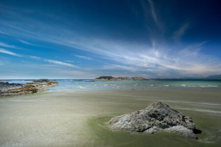
This long, sandy beach, spanning 16 kilometres along the west coast of Vancouver Island, is one of the earliest recorded surfing beaches in British Columbia. It is divided into three areas: Wikaninnish, Combers and Incinerator Rock. The seashore and surrounding forests offer many opportunities for exploration by naturalists.
From Combers Beach you can view Sea Lion Rock, a nesting haven for seabirds and a popular area for sea lions to hang out. If you are particularly interested in birds, loiter in the estuary at Combers Beach, where the river leaves the forest and enters the ocean. A mixture of salt and fresh water creates a nutrient-rich habitat, attracting birds. Trumpeter swans are known to frequent this area.
Migrating grey whales return from Mexico to the Pacific Northwest in the spring; stroll the beach in March for the best chance to see one. Other cetaceans you may spot include humpback whales, orcas and a variety of porpoises.

Hollows in rocky outcroppings create sanctuaries at low tide for sea stars, anemones and the occasional small fish. Safe from marine predators, these critters are trapped in these small tidal pools until the ocean rises again to cover them. Organisms that have adapted to live in tidal pools are unique and hardy. They must be able to survive a wide range of temperatures and adjust to lowered oxygen levels as the sun heats the water and animals in the pools produce waste.

On Wick Road, at the southern end of the beach, you will find the Kwisitis Visitor Centre. Interpretive displays provide information about the natural history of the area and the Nuu-chahnulth First Nations. From here, access trails through the forest, which can provide a welcome respite from a hot day on the beach. You may see signs warning of dangerous riptides in the area, so swimming is not recommended in many places along this beach.
What Makes This Hot Spot Hot?
- Peering into tidal pools reveals sea stars, anemones and other interesting intertidal organisms.
- Migrating grey whales are frequently sighted in the spring on their way north from Mexico.
- Trails through the forest behind the beach offer interpretive signs and glimpses of the ocean between large trees.
West Coast Trail
(Vancouver Island and the Coast) – Pacific Rim National Park Reserve

Address: Pacific Rim National
Park Reserve, between Port
Renfrew and Bamfield, BC
Tel.: (250) 762-4212
Website:www.pc.gc.ca/en/pnnp/bc/pacificrim/activ/activ6a
GPS Coordinates
Latitude: 48.57706
Longitude: -124.41772
Open from May to September
The West Coast Trail, 75 kilometres of breathtaking scenery, draws hikers from across North America. This nature hot spot is worth the preparation it takes to hike and camp for about five nights. The trail meanders in and out of old-growth forest, spending some time among towering cedars, and then moves to the rocky and sandy beaches.
As hikers pass by the old-growth cedar trees they may notice some have strips of bark missing. These trees are culturally modified, meaning the bark was stripped for cultural purposes, often strips would have been used by local First Nations for many types of weaving. Some of these large cedar trees were also cut and hollowed to create dugout canoes.
Having a tide table handy is necessary both for safety while hiking and so hikers can visit the beaches at low tide. On sandy or rocky beaches there is an abundance of intertidal treasures. It is no wonder low tide was referred to by various First Nations as “the table being set.” Gooseneck barnacles and mussels cling to rocks, and crabs scuttle about the sand. Search for tidal pools where anemones, bright purple sea urchins and a wide variety of sea stars and algae make their homes.

The views along the trail do not disappoint. One of the most picturesque campsites along the hike is near the stunning Tsusiat Falls, where fresh water cascades out of the forest and onto a beach. In addition to being beautiful, the West Coast Trail is rich in history. It runs through the traditional territories of three Nuu-chah-nulth Nations: Huu-ay-aht, Ditidaht and Pacheedaht. The rocky coastline was responsible for many shipwrecks in the 19th and 20th centuries, and so eventually lighthouses, telegraph wires and shelters for shipwreck victims were established along this trail, which at the time was named the Dominion Life Saving Trail.
The West Coast Trail is a through-hike going from Port Renfrew to Bamfield and does have a shuttle linking the two locations. It is well maintained by Parks Canada and requires a fee from hikers. Ladders, bridges and campsites are all in amazing condition.
What Makes This Hot Spot Hot?
Rich with history, this lifesaving trail travels through the traditional territories of three Nuuchah-nulth First Nations.
Visitors can hike through coastal rainforests and bogs and along seashores with tidal pools, all over the course of three to seven days.
Whales and other marine mammals are frequently sighted from shore.

Brandywine Falls
(Lower Mainland) – Brandywine Falls Provincial Park
Rushing water flows from the forest into a cavernous basin surrounded by steep rock walls.

Address: Brandywine Falls
Provincial Park, Whistler, BC
Tel.: (604) 986-9371
Website: www.env.gov.bc.ca/bcparks/explore/parkpgs/brandywine_falls
GPS Coordinates
Latitude: 50.035992
Longitude: -123.119505
Open year-round
Whistler is known primarily as a skiing destination, but it is surrounded by natural beauty. Brandywine Falls Provincial Park is just south of Whistler and makes for a beautiful day trip. The falls can be reached on relatively easy trails that are a short distance from the parking lot. The Brandywine Creek exits the pine forest abruptly and cascades 70 metres into a large basin surrounded by steep, rocky cliffs. The surrounding lodgepole pine forest is rare for coastal British Columbia, an area that generally boasts moist cedar forests. You may feel like you are travelling through an Interior forest, without the road trip. Glaciers shaped this landscape, wearing down the volcanic rock that the river and surrounding water bodies now occupy. With multiple viewing platforms a short distance from the trailhead, this waterfall is a stunning example of the beauty of British Columbia. Brandywine Falls is a spectacular sight in both summer and winter.
Snowshoers frequent the area during the winter months. Although the parking lot gate is not open during winter, a parking area alongside the road remains plowed. In the winter the basin is filled with snow and splash-back from the waterfall freezes on the surrounding rock faces, leaving icicles hanging from rocky outcrops.
More trails in the park lead to lakes, streams and marshy areas. Combined with the forest this area creates a perfect habitat for the northern red-legged frog. A medium-sized frog named for its red underbelly and hind legs, the red-legged frog is a blue-listed species in British Columbia. Found only along the southern coast of the Mainland and throughout Vancouver Island, these frogs prefer damp forests with slow moving water. Keep an eye out for them on the meandering trails as they spend most of their adult lives hiding under forest debris, only returning to water to hunt and breed.

What Makes This Hot Spot Hot?
- The forest is a protected area for red-legged frogs, a blue-listed species.
- Visitors get multiple viewpoints of the 70-metre waterfall carving its way through volcanic basalt rock.
- Dense pine forests, rare for coastal British Columbia, allow you to view a unique environment normally associated with the Interior.
George C. Reifel Bird Sanctuary
(Lower Mainland)
Each year lesser snow geese arrive at their winter home and blanket the sanctuary.

Address: 5191 Robertson Road,
Delta, BC
Tel.: (604) 946-6980
Website: www.reifelbirdsanctuary.com
GPS Coordinates
Latitude: 49.09845
Longitude: -123.17847
Open year-round
Each spring and fall, during migration, thousands of shorebirds take refuge in the 300 hectares of the George C. Reifel Bird Sanctuary. The marshes, fields and sloughs of the protected area are a year-round attraction for birders, and the sanctuary is considered one of the top 10 birding destinations in Canada. To avoid the crowds visiting this popular spot, try to plan your trip on a weekday. The blinds located at multiple spots around the marsh make for great viewing opportunities, and the raised dykes provide the perfect setting for an early morning stroll.
Although the spring and fall are assumed to be the most exciting times to visit the sanctuary, its most famous visitors appear in the winter, marking their own arrival with enthusiastic and sometimes deafening honks as they lay claim to the surrounding fields and wetlands. Tens of thousands of lesser snow geese descend on the sanctuary in the late fall after completing their lengthy journey from Russia’s Wrangel Island high in the Arctic. Despite arriving by the thousands, these giant gangs of geese may sometimes be difficult to spot because they do not stay in one place for the entire winter. If you cannot find them while walking the trails through the sanctuary, check the fields and estuaries that surround the marsh, since early morning disturbances can shift the birds to new locations. Look out for groupings of geese that include several greyer individuals — this is likely a family unit who made the journey together. The grey birds are part of the summer’s brood yet to fully transition into their snowy white plumage.

Roosting during the daylight hours after a night of hunting, one of the smallest members of the owl family is frequently found in the sanctuary in winter. The northern saw-whet owl is an absolute delight to see, and thankfully it does visitors a favour by roosting close to eye-level along the sanctuary trails. This small, bark-coloured bird with its dramatic white angled brow and cat-like eyes may be found on lower branches of western redcedar and Douglas-fir, or well hidden in holly.
Be very careful not to disturb the owls, even though they may be roosting close to the trail — they are trying to avoid larger predators and conserve energy until the night. By pointing out their roosts, you might accidently bring their presence to the attention of nearby passerines who will be sure to harass them until they leave the area. These enchanting owls are seldom seen despite their extensive range, and saw-whets are not often found here in the fall, so visit from December to March for your best chance to see one of Canada’s most endearing owls.

What Makes This Hot Spot Hot?
- Tens of thousands of lesser snow geese spend the winter here.
- Northern saw-whet owls roost along the trails during the day.
- Migratory birds stop over in huge numbers every spring and fall.
Reprinted with Permission from 100 Nature Hot Spots in British Columbia: The Best Parks, Conservation Areas and Wild Places By Lyndsay Fraser and Christina Smyth and Published from Firefly Books.


